18°13'0" N
63°0'0" W
~0m asl
23:02 (AST - UTC/GMT--4)
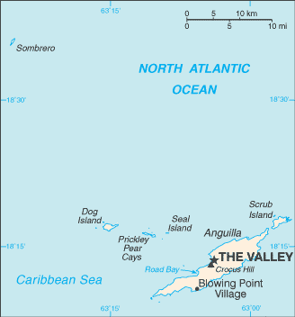
Sea Feather Bay (Sea Feather Bay) es un/una cala (s) (class H - Hidrográfica) en Anguilla (general), Anguila [ Reino Unido ] (North America) con un código de región de Americas/Western Europe.. y su población es de 3,292.
Sus coordenadas son 18°13'0" N y 63°0'0" W en formato DMS (grados, minutes, segundos) o 18.2167 y -63 (en grados decimales). Su posición UTM es NF01 y su referencia Joint Operation Graphics es NE20-06.
La hora local actual es 23:02; el sol sale a las 08:53 y se pone a las 21:00 hora local (America/Anguilla UTC/GMT-4). La zona horaria de Sea Feather Bay es UTC/GMT-4
En 2024 el horario de verano comienza el - y termina el -.
A Cala (s) es un pequeño orificio costeras, más pequeña que una bahía.
|
Advertisements:
Advertisements:
|
El tiempo Sea Feather Bay (Nubosidad, Temperatura, Velocidad del viento y Precipitación mm probab.)
Sat
Apr 27
26 °C min
27 °C max
22 km/h
Thu Jan 1
|
Sun
Apr 28
~5 l/m2 46%
26 °C min
27 °C max
33 km/h
Thu Jan 1
|
Mon
Apr 29
~6 l/m2 36%
25 °C min
27 °C max
37 km/h
Thu Jan 1
|
Tue
Apr 30
~9 l/m2 53%
25 °C min
27 °C max
39 km/h
Thu Jan 1
|
Wed
May 1
~5 l/m2 35%
25 °C min
27 °C max
29 km/h
Thu Jan 1
|
Thu
May 2
~12 l/m2 70%
26 °C min
28 °C max
31 km/h
Thu Jan 1
|
|
|
Sea Feather Bay (Anguilla (general)) 7 días de previsión
Mapa y Fotos Sea Feather Bay
--- No hay comentarios ---
Anade un comentario nuevo::
|
Login
Anguila [ Reino Unido ] (Overseas Territory):
Advertisement
GPS puntos cerca de Sea Feather Bay
GPS puntos de Anguila [ Reino Unido ] (Overseas Territory)
|
 Long Path (1 km)